
2026 Street Work and Maintenance

Maintaining & IMPROVING ACCESSIBILITY ON OUR LOCAL StreetS
CURRENT STATUS (LAST UPDATE: JULY 30, 2026)
The City of Port Townsend has completed several planned 2026 roadway improvement projects including the San Juan Rehabilitation Project, spot patching, chip sealing, and roadway shoulder improvements. The final phase of these projects is roadway re-striping. The proposed striping plans have been developed based on community feedback received during Active Transportation outreach events and in accordance with the City's Complete Streets Policy. These improvements are intended to enhance safety, accessibility, and connectivity for all roadway users, including pedestrians, bicyclists, transit riders, and motorists.
Council Presentation and Public Comment - August 3rd | Council Decision - August 17th
The proposed striping plans will be presented to the City Council before the new markings are installed. Community members are encouraged to attend and provide comments. Meeting time, location, participation information, and agenda materials will be posted on the City website before the meeting.
Sheridan Avenue Striping Plan:
Complete Streets Improvements Under Public Review
The plan is still a draft and may be adjusted based on public input, Council direction, and agency review.
Project Overview and Existing Conditions:
The proposed plan covers Sheridan Avenue from SR 20 to Discovery Road/19th Street intersection. Existing striping along the street corridor includes discontinuous bicycle lanes, varying width buffer areas, and multiple parking configurations. The proposed layout would provide more consistent and clearly defined travel lanes, bicycle lanes, parking areas, pedestrian space, and crossings.
Based on the existing roadway width, the proposed layout will “right-size” the street to provide vehicle travel lanes, bicycle lanes with buffers, parking, and pedestrian areas adjusted to fit the conditions of each block. The improvements would be made primarily through pavement markings and signs within the existing street width; no roadway widening is proposed.
Why Is the City Considering These Changes?
Sheridan Avenue recently received a chip seal surface treatment this summer and will need to be restriped afterward. This creates a cost-effective opportunity to improve the layout while the pavement markings are already being replaced. The draft plan is intended to make better use of the existing road width while balancing these needs along the street corridor.
| Sheridan Avenue Segment | Draft striping change |
| SR 20 to 7th Street (QFC/Manresa Castle | Continuous bicycle lanes with buffers and the removal of on-street parking near SR20, parking at Manresa Castle will remain unchanged. Right turn only from Sheridan Avenue onto SR 20. |
| 7th to 10th Streets (Hospital) | Addition of on-street parking near the hospital and transit stop, continuous bicycle lanes with buffers, and shift parking flush with curb. |
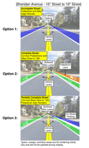
| 10th to 15th Streets (Residential) | Three options will be presented for City Council decision: Option 1: Vehicle lanes and on-street parking Option 2: Vehicle lanes, bicycle lanes with buffers, east side pedestrian lane (Complete Streets) Option 3: Vehicle lanes, bicycle lanes with buffers, east side on-street parking (Partially Complete Streets) |
|
15th Street to Discovery Road/19th Street (Residential/Elementary School) |
Re-stripe the existing bicycle lanes and pocket parking configuration while improving the consistency and definition of lane markings. |
10th Street to 15th Street options presented to City Council:
SR 20 Intersection Concept:
The draft materials also show potential changes at the SR 20/Sheridan Avenue intersection including: relocated pedestrian crossings, Sheridan Street and SR 20 intersection closure, and a proposed right turn only from Sheridan Avenue onto SR 20. This portion remains conceptual, requires Washington State Department of Transportation approval, and would not be implemented until that review is completed.
Sheridan Street Intersection Closure and SR20/W Sims Way Safety Improvements:
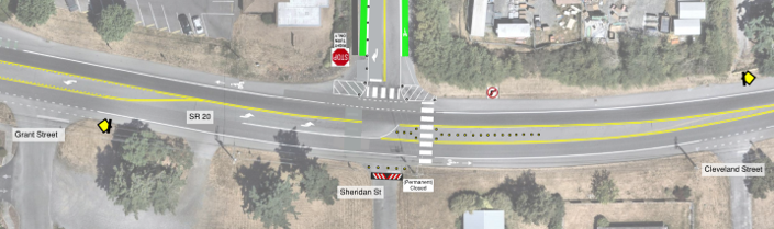
Proposed Striping Plan layout and safety improvements.
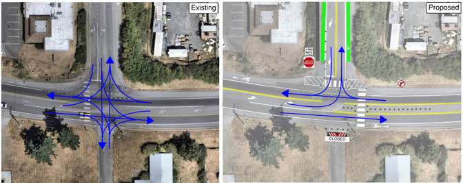
Existing and proposed vehicular movements at Sheridan and SR20
For a complete overview of the proposed Sheridan Avenue Striping Project, including the proposed roadway layout, parking modifications, project renderings, and planned SR 20 intersection improvements, please review the attached PDF below.
Difficulty of Left Turns from Southbound Sheridan onto Sims
Left turns from southbound Sheridan onto Sims can be a challenge. This video shows a car waiting nearly 90 seconds to make the left turn. Today, there is a shared left/through lane and a dedicated right turn lane. Highlights of the video:
- The car inches forward, looking for an acceptable gap, blocking the bike lane and forcing the cyclist to stop then ride in the Sims vehicle lane
- The car completed the left turn forcing the Sims traffic to slow
- The slow down on Sims led to driver aggression
- While the car waited 90 seconds to turn left, 4 cars turned right from Sheridan to Sims. Sheridan would back up if this were a combined left and right turn lane
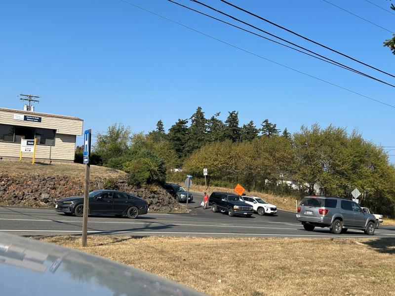
Photo Above: Pedestrian crossing Sheridan Street.
This video was shot by Public Works on Tuesday August 18th between 3:50 and 4:50.
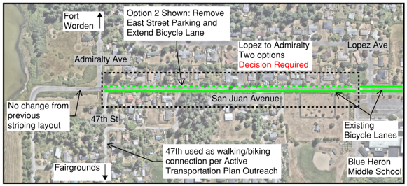
San Juan Avenue Striping Options:
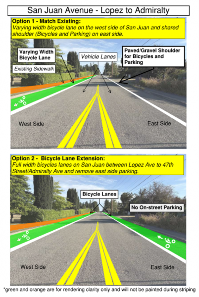
San Juan Avenue recently underwent a roadway rehabilitation project from Blue Heron Middle School to Admiralty Ave. Between Lopez Avenue and Admiralty Avenue, two pavement striping options are being considered:
Option 1 – Existing Configuration
- Match the existing striping layout.
- Paved/Gravel Shoulder for bicycles and parking
Option 2 – Bicycle Lane Extension
- Bicycles lanes on both sides of the roadway with no on-street parking.
Monroe Street Striping Options:
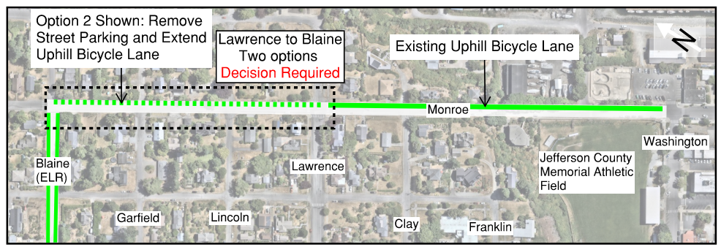
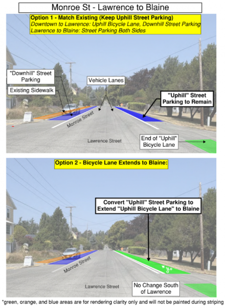
Monroe Street recently received a chip seal surface treatment starting at Water Street up through Jackson Street. Between Lawrence Street and Blaine Street, two pavement striping options are being considered:
Option 1 – Existing Configuration
- Match the existing striping layout.
- Maintain on-street parking on both sides of Monroe Street.
Option 2 – Bicycle Lane Extension
- Maintain on-street parking on the “downhill” (downtown-bound) side of Monroe Street.
- Convert the “uphill” on-street parking lane to an “uphill” bicycle lane to Blaine Street.
Questions?
Please contact:
- Jeff Kostechka, Assistant City Engineer – (360) 302-2192 | jkostechka@cityofpt.us
- Mark Greer, Civil Engineer – (360) 358-5954 | mgreer@cityofpt.us
Updates
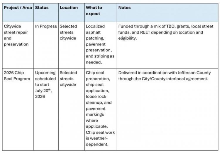
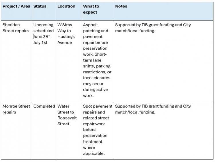
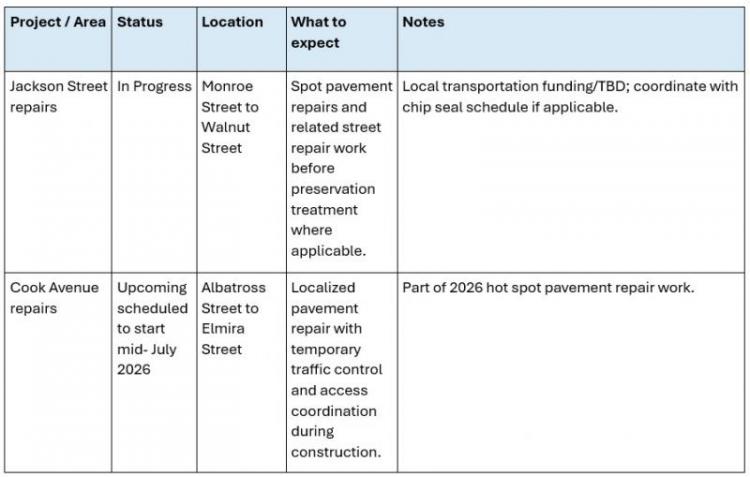
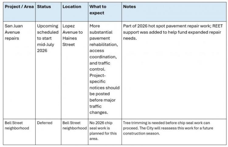
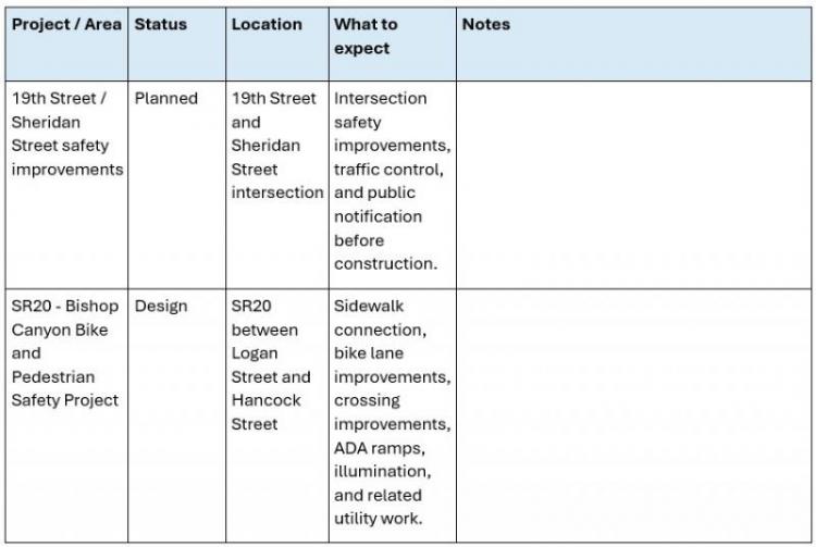
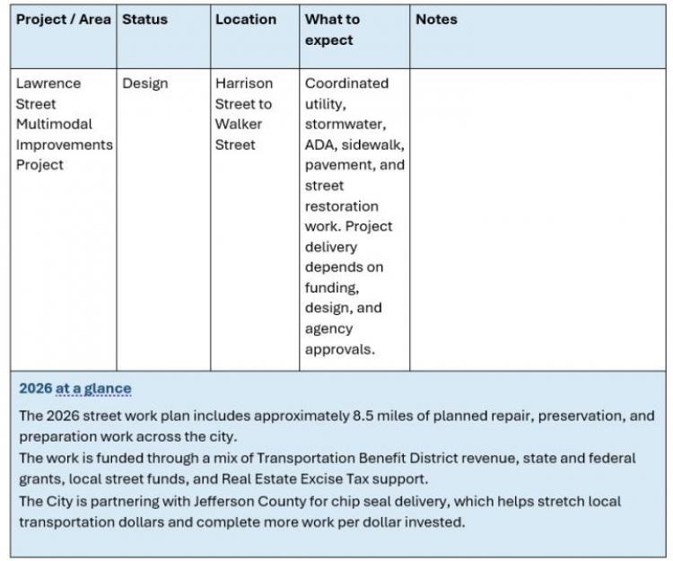
2026 Street Work Overview
Planned 2026 street work locations. Final schedules may change due to weather, contractor availability, grant approvals, traffic control needs, and field conditions.
How this work is funded
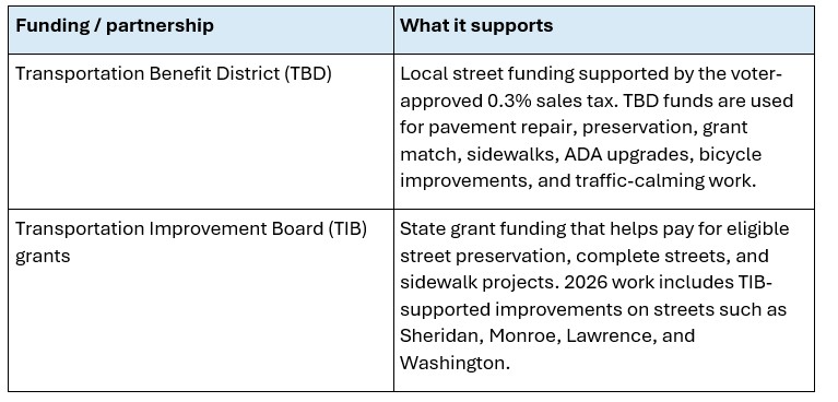
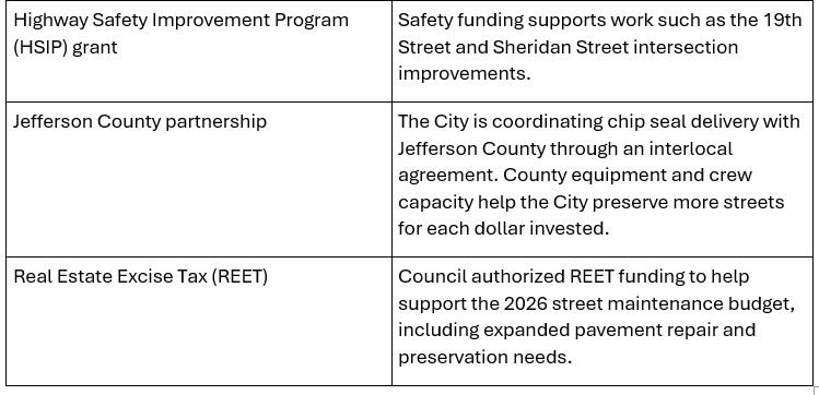
The City uses several funding sources to deliver street repair, preservation, safety, and accessibility improvements. Combining local funds with grants and partnerships allows the City to complete more work than local funding could support on its own.
Questions or Concerns?
Why the City partners with Jefferson County
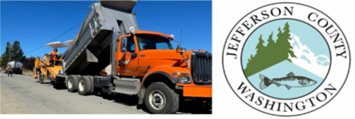
The City and Jefferson County are working together on chip seal and related preservation work. This partnership gives the City access to specialized equipment, experienced crews, and an efficient delivery model for pavement preservation.
- Helps complete more street work with available local funding.
- Reduces the need to separately bid every small preservation segment.
- Improves coordination between nearby city and county pavement-preservation work.
- Supports a regular, repeatable approach to chip seal and street preservation.
What to expect during street work
- Temporary lane shifts, flaggers, single-lane traffic control, or short-term closures near active work areas.
- Posted no-parking notices or temporary access changes where crews need room to work.
- Noise, dust, loose rock, pavement edges, and heavy equipment during construction hours.
- Weather-dependent schedule changes for chip seal, paving, striping, and similar work.
- Driveway access may be delayed for short periods while crews work directly in front of a property.
- Emergency access will be maintained. Please follow posted signs and directions from traffic-control staff.
.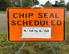
Image caption: Temporary traffic control helps crews work safely while maintaining local and emergency access.
Why this work matters
Street work is more than paving. The City uses street repair and preservation projects to extend pavement life, improve safety, improve accessibility, support walking and biking, and reduce long-term repair costs.
- Pavement preservation keeps streets in service longer and helps avoid more expensive reconstruction.
- Patching and spot repairs address failed pavement before chip seal or other surface treatments are applied.
- Drainage improvements protect the street base and extend the life of pavement.
- Sidewalk, crossing, and ADA improvements help make streets safer and more accessible.
- Traffic-calming and bike/pedestrian improvements support the City’s safety and transportation goals.
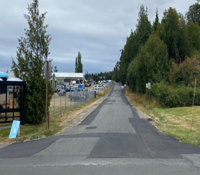
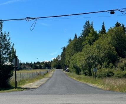
Image caption: Pavement preservation and spot repairs help extend street life and reduce the need for more costly reconstruction.
Before work begins near your property
Property owners can help crews work safely and efficiently by preparing frontage areas before construction or chip seal work begins.
- Trim vegetation that hangs into the sidewalk, shoulder, or roadway. See Right-of-Way Maintenance Requirements below.
- Keep ditches, culverts, and drainage paths clear of yard waste and debris.
- Move vehicles, trailers, basketball hoops, garbage cans, and other personal items out of the work area when notices are posted.
- Watch for temporary no-parking signs, door hangers, reader boards, and web updates.
- Contact Public Works before doing work in the right-of-way; some vegetation, drainage, or frontage work may require a permit.
Chip seal: what residents should know
Chip seal is a pavement-preservation treatment that places oil and small rock on the street surface. It helps seal and protect the pavement and can extend the life of a street when applied at the right time.
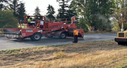
Chip Seal Process: Chip seal preserves pavement by applying asphalt emulsion and rock, followed by rolling and sweeping.
- Chip seal is not the same as full pavement reconstruction.
- Loose rock is expected immediately after application. Crews return to sweep the street after the rock has had time to embed.
- Please drive slowly on newly chip-sealed streets and avoid sharp turns, sudden braking, and parking on fresh material when directed.
- Schedule changes are common because chip seal depends on dry weather, pavement temperature, and crew availability.
- Some streets need pavement repair, drainage work, vegetation trimming, or other preparation before chip seal can be applied.
Frequently asked questions
How do I know if work will affect my street?
Check this page and the City Projects map. Each update should include the project location, status, expected timing, and traffic impacts.
Will I still be able to get to my home or business?
Most access will be maintained, but short delays may occur while crews work directly in front of a driveway, intersection, or narrow street segment. Follow posted signs and directions from flaggers.
Why are some projects about sidewalks, crossings, or bike lanes instead of only paving?
Street projects often combine pavement repair with safety, accessibility, drainage, and mobility improvements. Coordinating this work helps reduce future disruptions and supports the City’s Complete Streets policy.
Why do dates change?
Street work depends on weather, material availability, crew scheduling, equipment, grant requirements, and field conditions. Chip seal, paving, and striping are especially weather-dependent.
Why is Bell Street not being chip sealed this year?
Bell Street neighborhood chip seal work was deferred from 2026 schedule because tree trimming is needed before chip seal work can proceed. The City will reassess this work for a future construction season.
How is this work paid for?
The City combines Transportation Benefit District revenue, grants, local funds, REET, and partnerships such as the Jefferson County chip seal partnership to complete as much priority street work as funding allows.
How do I report a pothole, drainage issue, sign problem, or street hazard?
Use the City’s Report a Concern form for non-emergency issues at Report A Concern . Call 911 for life-safety emergencies or hazards that require immediate emergency response.
Report a problem or ask a question:
For non-emergency street concerns, use the City’s Report a Concern form: Report A Concern
Related resources
- City Projects Maps: City Projects Maps
- Transportation Benefit District annual report can be found here:Transportation Benefits District Annual Report
- Comprehensive Streets Program. More info can be found here: Comprehensive Streets Program
- Engineering and Construction page: Engineering and Construction
- Right-of-Way Maintenance Requirements: Right of Way Maintenance Requirements
- Trees in the Right-of-Way: Trees in the Right of Way
- Landscaping in the Right-of-Way: Landscaping in the Right of Way
Supporting Documents
 City Street Work 2026 (1007 KB) Traffic Control Plan (223 KB) San Juan Avenue Neighborhood Letter (659 KB) Cook Avenue Neighborhood Letter (807 KB)
